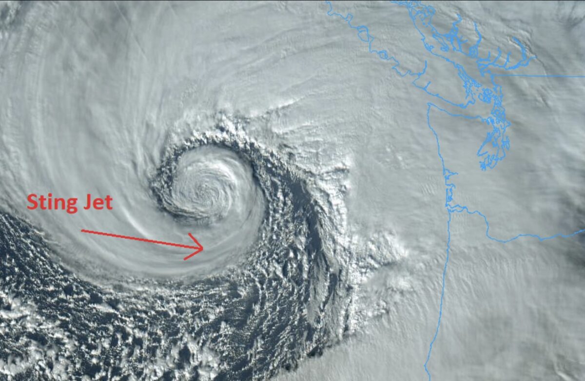
A “bomb cyclone” billed as one of the strongest storms on record to hit the Pacific Northwest is slamming Washington, Oregon, and Northern California with a medley of severe weather conditions this week.
The storm, featuring a so-called “atmospheric river,” unleashed strong winds and rain that knocked down trees and reportedly caused power outages for hundreds of thousands of people. Local residents were also warned of the potential for flash floods, blizzard conditions, rock slides, and debris flows.
🌧 ❄ A significant AR is ongoing across parts of the Northwest. Here is a list of some rain and wind reports so far. For additional information, please refer to our storm summary (which will be updated every 12 hours through the event): https://t.co/mSj0gRYjKE pic.twitter.com/HuKWcd0JIg
— NWS Weather Prediction Center (@NWSWPC) November 20, 2024
At least two people have been killed by the bomb cycle. The Bellevue Fire Department in Washington said on X that a tree fell onto a home and killed a woman. And South County Fire in Washington, a regional fire authority, reported a “large” tree fell on a homeless encampment in Lynnwood and killed a woman in her 50s.
Reporters from local news stations shared images of the destruction on X, including video of a large tree that fell onto a car that prompted Seattle Fire Department crews to rescue one person who was trapped inside.
Tree fell on this home in Sammamish on 258th Ave SE @KING5Seattle pic.twitter.com/y41mIZ3BND
— Madison Wade (@madisoncwade) November 20, 2024
BREAKING: Seattle Fire is working to remove a car that’s trapped under a tree near NE 100th St and 35th AVE NE @komonews https://t.co/TTfw3cQs84 pic.twitter.com/pTV6heO8jD
— Hannah Knowles (@HannahknowlesTV) November 20, 2024
The National Ocean Service says a “bomb cyclone” forms through a process called bombogenesis in which “a midlatitude (the latitudes between the tropics and polar regions) cyclone rapidly intensifies, or strengthens, over a 24 hour period.” It can happen “when a cold air mass collides with a warm air mass, such as air over warm ocean waters.”
“BOMB CYCLONE” cranking up right now with pressures comparable to a Category 3 or 4 hurricane (944 mb) off the coast of the Pacific Northwest. This storm will continue to bring an atmospheric river to California, Oregon, Washington and British Columbia with heavy rain, feet of… pic.twitter.com/PQqswC0lWp
— Matt Devitt (@MattDevittWX) November 20, 2024
With pressure low enough to match that of a powerful hurricane, the bomb cyclone that formed this week developed a massive swirl off the Pacific Northwest coastline, as shown in satellite imagery.
MATT WALSH’S ‘AM I RACIST?’ NOW STREAMING ON DAILYWIRE+
In a post to X, the National Weather Service (NWS) pointed to the swirl and said that some “of the most powerful winds with the strong low pressure offshore are often in a region called the ‘Sting Jet’ (not a Police tribute band). Also known as the ‘Poisonous Tail’ – it’s where strong winds form as colder dense air rapidly descends and dries.”
Some of the most powerful winds with the strong low pressure offshore are often in a region called the “Sting Jet” (not a Police tribute band). Also known as the “Poisonous Tail” – it’s where strong winds form as colder dense air rapidly descends and dries. #wawx pic.twitter.com/2kMTtu0nvc
— NWS Seattle (@NWSSeattle) November 19, 2024
A separate area of low pressure was expected to develop and quickly strengthen off the Northwest coast on Friday, helping to “amplify the atmospheric river streaming into northern California through Friday morning, exacerbating the flooding threat,” the NWS Weather Prediction Center said in a discussion post on Wednesday.
Noting there is a risk of intense rain and “another round of strong winds” from the second low-pressure system into the end of the week, the Weather Prediction Center added: “Residents and visitors residing or traveling between northern California and Washington are advised to check road conditions before venturing out, listen to advice from local officials, review emergency plans, and have multiple ways of receiving warnings.”

